Long-form / 深度專題
城市規劃與新市鎮:由一幅大綱圖到新發展區
Urban planning and new towns: from an outline plan to new development areas
香港嘅市區同新市鎮,係點樣被「劃」出嚟?
香港嘅城市形態唔係自然長出嚟:有人劃線,有人定用途,有人負責收地同填海。1922 年港府成立城市規劃委員會,1939 年通過條例把法定圖則嘅權力交給它;戰後一份外來顧問報告把「開發新市鎮」寫成政策方向,1955 年觀塘衞星城市大綱圖就係第一次落地。此後荃灣、屯門、沙田、將軍澳各自用一條公共屋邨標示「有人入住」,而市區一邊就由土地發展公司走到市區重建局。
約 4 分鐘 · 5 節 · 16 條時間線 · 4 份文獻
English
1. The planning system: a board first, statutory power later
Hong Kong’s planning system begins with a board. In 1922 the Town Planning Board was established by the Government to prepare development plans. A board needs legal standing before a plan can bind anyone: on 30 June 1939 the Town Planning Board was formally constituted to design the layout of present and future urban areas, and the Town Planning Ordinance passed that year — amended several times since — gave it statutory power to prescribe land use through statutory plans and to control development.
Once the system existed, a report set its direction. In September 1948 the Government published a planning report by the British architect Abercrombie recommending three lines of long-term planning: improving internal and external transport, developing new towns to disperse the urban population, and improving town planning legislation and land-use zoning.
The three lines are worth remembering one by one, because Hong Kong planning ran on those rails for decades: transport, new towns, law and zoning. The year matters too — with population surging after the war, planning was no longer about beautifying a city but about housing people.
2. Satellite cities: Kwun Tong went first, Tsuen Wan followed
In 1955 the Government formulated the outline plan for the Kwun Tong satellite city, marking the beginning of new town development in Hong Kong. Kwun Tong also became the template for later new towns, and its method was plain: reclaim land to create usable sites, then place industry and housing together so that residents would not face a long commute every day.
Tsuen Wan was the second trial and came closer to the full shape of a new town. In 1959 the Housing Society completed Four Seasons Estate, the first public housing estate in Tsuen Wan New Town; from the same year the Government began building the new town, reclaiming land at Gin Drinkers Bay and around Tsuen Wan for industry and housing.
Note the order: an outline plan first, reclamation second, and only then estates with people moving in. That order explains why “new town” in Hong Kong is an engineering concept and not merely a place name — behind every estate stands a plan and a batch of reclamation works.
3. Writing numbers into the plan: population and land area
The decisive step in any new town is writing the population target into a statutory plan. On 1 September 1961 the Town Planning Board published an outline draft plan for Tsuen Wan, the first statutory plan for that new town, planning to develop it over fifteen years into a self-sufficient satellite city with a stated population target.
That sentence contains three testable promises: time (fifteen years), scale (640,000 people) and character (self-sufficiency). Remove any one and the plan is only a map. Because those figures were written down, later reviews had a baseline — whether actual population reached the target, whether jobs were enough, whether cross-district commuting fell.
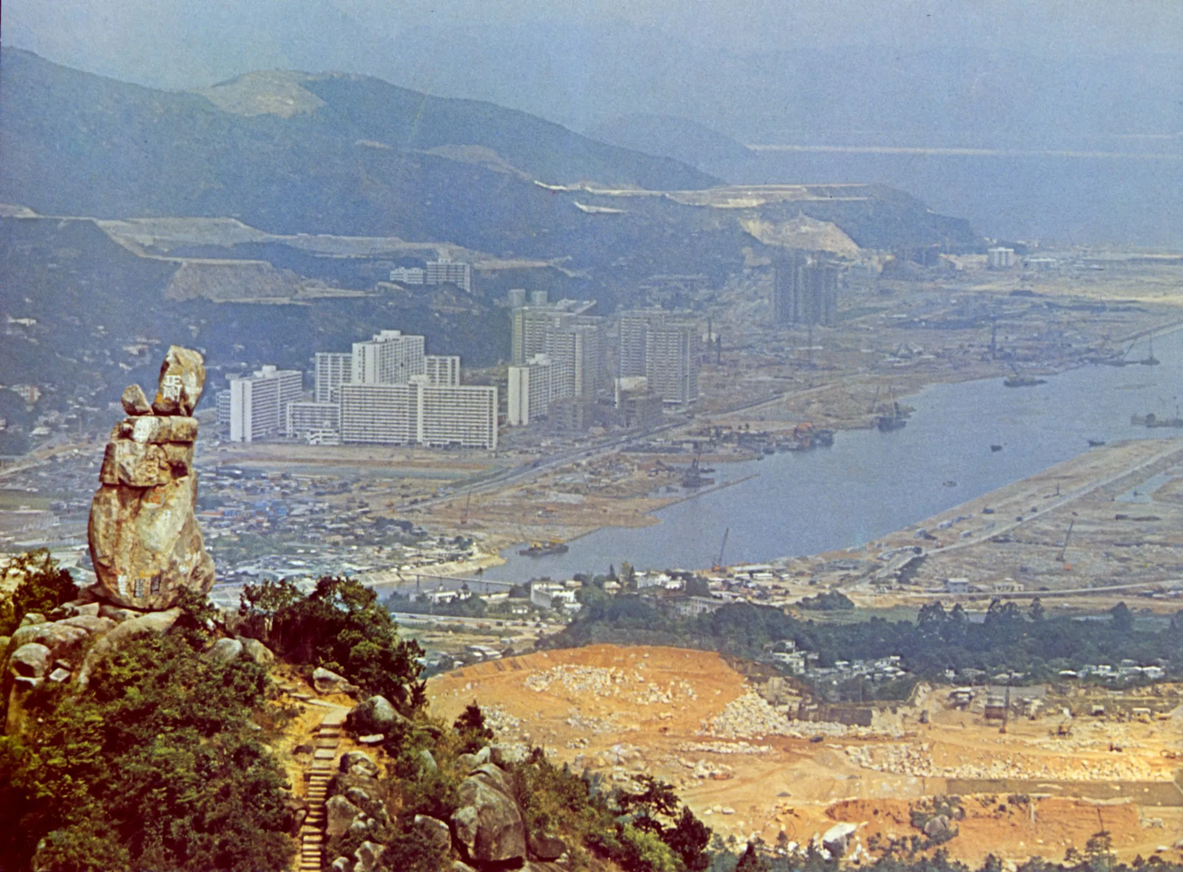
Tuen Mun, then called Castle Peak, took the same route but measured scale in reclaimed land: in March 1966 the Government launched the first phase of the Castle Peak new town programme, involving 220 acres of reclamation to build housing for 100,000 people and to promote industry. By the early 1970s construction of the first batch of new towns was under way, covering Tsuen Wan, Sha Tin and Tuen Mun — three places, three plans, one method.
4. An estate as a date marker: Lek Yuen and Po Lam
The most reliable marker of when a new town really began is not the gazetting of a plan but the first public estate taking in residents. For Sha Tin the marker is July 1975, when Lek Yuen Estate, built by the Housing Authority, was formally occupied as the first public estate in the new town.
For Tseung Kwan O the marker is 26 February 1988, when Po Lam Estate was occupied as the first public estate there. On 26 May the same year the Government announced that the third phase of the Tseung Kwan O new town programme would cover the Rennie’s Mill squatter area — a reminder that a new town is not drawn only on empty land; existing squatter areas had to be absorbed, bringing resettlement and compensation with them.
Using an estate as a marker has a methodological advantage: occupation dates are recorded and can be checked one by one, which is far more solid than saying that a new town “began to develop”. The limit must be stated too — the first estate marks the arrival of the first residents, not the simultaneous arrival of roads, schools and clinics; services usually lag, and that gap is the most frequent criticism of Hong Kong’s new towns.
5. The urban side: renewal, Metroplan and new development areas
New towns answered the question of where the extra population would live; the built-up area had to answer what to do with old districts. On 15 January 1988 the Land Development Corporation took on urban renewal projects, supported by the Government and operating on prudent commercial principles — the phrase is the key: renewal was not a social service and had to add up.
On 22 November 1991 the Government published the Metroplan, a conceptual framework for future urban development proposing large-scale reclamation, redevelopment and infrastructure in the urban area. On 1 May 2001 the Urban Renewal Authority replaced the Land Development Corporation, launching a twenty-year urban renewal programme covering twenty-five incomplete projects and adding two hundred new ones — a combination of figures showing that replacement is not a fresh start; old projects carry over.
The land supply battleground then moved to the New Territories and the former airport site. In 2007 the SAR Government launched the Kai Tak Development, building a new community on the former airport land; on 4 July 2013 it announced the results of the planning and engineering study for the North East New Territories New Development Areas; and on 19 June 2015 the Chief Executive in Council approved the two outline zoning plans for Kwu Tung North and Fanling North, allowing the planning to proceed. From “satellite city” to “new development area” the name changed, but the method did not: plan, resume, reclaim, then wait for people to move in.
Gaps
- This dossier does not compare planned population with actual population: the definitions and reference dates differ, and census and Planning Department documents have not been verified item by item, so it states what the plans wrote rather than how many people eventually lived there.
- Figures for land resumption, compensation and rehousing (including squatters, squatter huts and farmland) are not registered year by year; the prose notes only that the Rennie’s Mill area was brought into the plan.
- Reclamation areas and costs exist only as individual figures in the source volume; they have not been assembled into a comparable series, and no total is added to the prose.
- Environmental impact assessment and statutory procedure (strategic EIA, board representations) are not developed item by item; any detail would first require verification of the EIA reports and board papers.
- The official definitions of “new town” and “new development area” belong to different periods; this dossier follows the source’s usage and does not set up a separate definition table.
- Recent spatial plans such as the Northern Metropolis are not registered in the chronicle, so this dossier gives no year and no scale for them, and the gap is stated as it stands.